Summary
Every winter, millions of parents, students, and school administrators anxiously await one decision: will tomorrow be a snow day? Behind that decision lies a fascinating contest between seasoned human meteorologists armed with decades of local knowledge and cutting-edge algorithmic snow day predictors powered by machine learning and numerical weather models. This article, Human vs Algorithm: Who Predicts Snow Days Better, explores how both approaches work, where each excels or fails, examines the science behind the snow day calculator formula, and ultimately reveals what the research says about which method delivers more accurate school-closure forecasts.
Table of Contents
- Introduction: The Snow Day Forecasting Stakes
- How Human Forecasters Predict Snow Days
- How Algorithmic Snow Day Predictors Work
- Head-to-Head Comparison: Human vs Algorithm
- The Hybrid Model: Where Both Methods Meet
- Regional Spotlight: Ohio Snow Day Forecasting
- Tips for Parents: How to Use Both Methods Effectively
- Conclusion
Introduction: The Snow Day Forecasting Stakes
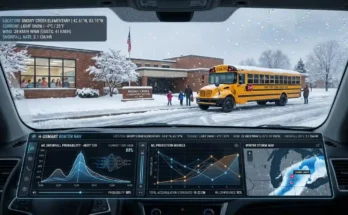
Picture this familiar winter scene: it is 10 p.m. on a Tuesday, a storm system is churning up the East Coast, and school superintendents across the country are sweating over a decision worth millions of dollars in lost instructional time — and equally priceless to every child dreaming of a morning off. The question sounds deceptively simple: Will it snow enough to cancel school?
For most of American history, the answer depended entirely on a human being — a local meteorologist or district official who combined official weather forecast data, road condition reports, and intimate knowledge of their community to make the call. Today, sophisticated algorithmic tools — including online snow day predictors and digital weather models — are challenging that traditional authority with remarkable precision.
This debate matters in very practical terms. Schools spend an estimated $1.2 billion annually making up for unnecessary snow days. False alarms create logistical nightmares for working parents, while missed calls leave children stranded on icy roads. Getting the forecast right is not merely a matter of scientific curiosity — it carries real consequences for communities, budgets, and safety.
Key facts worth noting before diving in:
- 72% of school districts use weather forecasts as the primary input for snow day decisions.
- 4 inches is the average snowfall threshold that triggers school closure in most U.S. districts.
- 24 hours is the critical forecast window — accuracy drops sharply beyond this range for both humans and algorithms.

How Human Forecasters Predict Snow Days
Long before computers could model the atmosphere with any reliability, human meteorologists developed the art and science of winter storm forecasting. A professional forecaster making a snow day prediction draws on a rich, layered toolkit that blends technology with irreplaceable human judgment.
At the core of their process is numerical weather prediction (NWP) — computer-generated models like the GFS (Global Forecast System), the ECMWF (European Centre for Medium-Range Weather Forecasts) model, and the NAM (North American Mesoscale) model. These models are a starting point, not the final word. A skilled human forecaster reads model output, identifies where models are likely to be wrong — a skill known as model bias correction — and layers in local knowledge to refine the prediction.
Strengths of Human Meteorologists
Local terrain expertise is perhaps the human forecaster’s greatest edge. A meteorologist who has spent years covering a specific region understands how local geography shapes snowfall patterns. Lake-effect snow near the Great Lakes, orographic lift along mountain ranges, and the unique urban heat island effect in dense cities — these nuances require years of observation to interpret correctly. No algorithm trained on regional averages can fully replicate this spatial intuition.
Situational meteorological awareness is another critical advantage. Human forecasters understand how current upper-level wind patterns, moisture flux from the Gulf of Mexico, or an approaching low-pressure system interact in ways that models sometimes mishandle — particularly during the setup of cut-off lows or rapidly evolving nor’easters. They can recognize when a mesoscale convective system is likely to intensify snowfall rates beyond what the synoptic model predicts.
Furthermore, human forecasters integrate non-meteorological data into their recommendations. Road surface temperatures, pre-existing ice from overnight re-freeze, the condition of a district’s bus fleet, and community risk tolerance all factor into the human advisory — none of which a purely meteorological algorithm naturally incorporates.
Limitations of Human Forecasters
Despite their strengths, human forecasters carry inherent limitations. Cognitive biases — including anchoring on initial model output, the availability heuristic (overweighting recent memorable storms), and risk aversion after public criticism — can skew predictions. Studies in forecast psychology show that meteorologists are measurably more likely to overpredict snowfall amounts, a pattern driven partly by the reputational cost of missing a major storm.
Consistency is another challenge. Two equally qualified forecasters reviewing the same data can reach meaningfully different conclusions. This variability is especially pronounced in the borderline range — storms that deliver 2 to 4 inches of snow, right in the ambiguous zone where a closure call is genuinely uncertain.
“The hardest forecast is not the blizzard. Everyone sees the blizzard coming. The hardest call is the borderline 3-inch storm with temperatures hovering at 30°F, because that storm breaks differently depending on which side of the highway you’re on.” — National Weather Service Forecaster, on winter storm ambiguity
How Algorithmic Snow Day Predictors Work
The rise of algorithmic snow day prediction tools represents one of the most interesting intersections of meteorological data science and public utility software. These tools — including popular online snow day predictor platforms — aggregate vast streams of weather data, apply statistical models, and output a probability score estimating the likelihood of school cancellation.
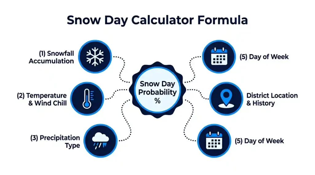
Understanding the Snow Day Calculator Formula
The snow day calculator formula is not a single universal equation but rather a class of probabilistic models that weight multiple atmospheric and geographic variables. While implementations vary between tools, the core logic of any robust snow day calculator formula typically incorporates the following inputs:
1. Forecasted Accumulation (inches): The primary driver. Historical school closure data consistently show that accumulation thresholds — typically 3, 4, or 6 inches, depending on the district — are the strongest single predictor of a snow day.
2. Temperature and Wind Chill: Even modest snowfall paired with extreme cold or dangerous wind chills elevates closure probability significantly. The wind chill factor and apparent temperature are weighted inputs, especially for early-morning departure windows when students wait at bus stops.
3. Precipitation Type and Timing: Freezing rain or ice accumulation is often more disruptive than an equivalent depth of snow. Algorithms trained on historical closure data learn to weight ice events more heavily than pure snowfall events of the same precipitation volume.
4. School District Location and Historical Behavior: Sophisticated tools encode regional and district-level history. A district in northern Minnesota operates with a much higher closure threshold than one in the Georgia Piedmont. This geographic calibration is what separates a well-designed snow day predictor from a naive snowfall lookup table.
5. Day of the Week and Proximity to Holidays: Behavioral data reveals that school districts are statistically more likely to cancel school on Fridays and the days immediately before winter or spring breaks — a subtle but measurable human bias that algorithmically-trained models now account for.
For a practical, easy-to-use implementation of these principles, the snow day calc applies region-specific probability models to help families get a reliable early estimate long before the official school announcement.
Strengths of Algorithmic Prediction
Consistency and objectivity are the algorithm’s cardinal virtues. Given identical inputs, a well-designed model produces identical outputs every time. There is no fatigue, no anchoring bias, no memory of the catastrophic storm two winters ago that made the forecaster overly cautious. This reproducibility is extraordinarily valuable for calibrated probabilistic forecasting, where reliability over thousands of predictions matters more than any single spectacular call.
Speed and scalability are equally compelling. A single algorithmic platform can simultaneously generate snow day predictions for every school district in the United States in seconds — a task that would require an army of regional meteorologists to approximate. This scalability enables platforms to serve hyper-local predictions that a broadcast network could never cost-effectively provide.
Machine learning models improve over time. Each winter season generates new ground-truth data — what actually happened versus what was predicted — and modern systems use that data to retrain and recalibrate their weights. The algorithm learns from its mistakes systematically, in ways that human forecasters, subject to memory limitations and career transitions, cannot replicate at scale.
Weaknesses of Algorithmic Prediction
Algorithms are only as good as their training data — and training data has blind spots. Black swan weather events — unprecedented storm configurations, unusual warm-air intrusions mid-blizzard, or rapidly intensifying nor’easters that exceed all model guidance — can produce catastrophically wrong algorithmic predictions precisely because such events are underrepresented in historical training sets.
Furthermore, algorithms cannot yet fully capture the administrative and political dimensions of snow day decisions. A superintendent facing community pressure after canceling too many days the previous winter, or a school facing a critical state testing date — these human factors influence actual closure decisions in ways that meteorological data alone cannot predict.
Head-to-Head Comparison: Human vs Algorithm
To make the debate concrete, here is how each method performs across the key dimensions that matter most in real-world snow day forecasting:
| Dimension | Human Forecaster | Algorithm / Snow Day Predictor | Edge |
| Local terrain knowledge | High — years of regional experience | Moderate — misses micro-topography | Human |
| Consistency across predictions | Variable — bias and fatigue | High — deterministic outputs | Algorithm |
| Extreme / novel storms | Good — recognizes anomalous setups | Poor — limited by training data | Human |
| Speed and scalability | Limited — one region per forecaster | Exceptional — national coverage | Algorithm |
| Non-weather contextual factors | Strong — roads, buses, community | Weak — meteorological data only | Human |
| Learning from past errors | Informal — memory-based | Systematic — model retraining | Algorithm |
| Probabilistic calibration | Moderate — improves with experience | High — statistically optimized | Algorithm |
| Short-range accuracy (0–24 hrs) | Very strong with local expertise | Strong with quality NWP input | Extreme/novel storms |
What the comparison reveals is that neither method dominates comprehensively. Humans win where nuance, local context, and novelty matter. Algorithms win where consistency, speed, and calibrated probability estimation are paramount.
The Hybrid Model: Where Both Methods Meet
The most forward-thinking approach in modern winter weather forecasting is not choosing between human expertise and algorithmic prediction — it is combining them strategically. This hybrid methodology uses algorithms for what they do best (rapid, consistent probability scoring across large geographic areas) while preserving the human role for high-stakes edge cases and contextual judgment.
The National Weather Service already practices a version of this model. Automated NWP model output statistics (MOS) generate baseline forecasts, which trained forecasters review, adjust, and annotate with qualitative guidance. The forecaster does not replace the model — they supervise it and correct its systematic errors.
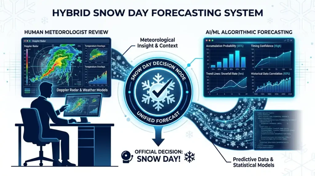
For individual families, the same logic applies. Checking a reliable online snow day predictor alongside your local television meteorologist’s report gives you the best of both worlds — a calibrated probabilistic estimate from the algorithm, tempered by the forecaster’s qualitative commentary about local conditions. Neither source alone tells the complete story.
💡 Pro Tip: The best practice for families is to cross-reference two data points — an algorithmic tool that provides a numerical snow day probability, and a local meteorologist’s commentary about road conditions and storm timing. When both sources agree, confidence is high. When they diverge, the storm is genuinely uncertain and real-time monitoring is advisable.
Regional Spotlight: Ohio Snow Day Forecasting
Ohio represents a particularly rich case study in the human-versus-algorithm debate. The state straddles two distinct meteorological regimes: the lake-effect snow belt in the northeast — where cities like Cleveland and Youngstown receive intense, localized snowfall from Lake Erie — and the more continental central and southern counties, where winter weather is more predictable but no less disruptive.
For families in the Buckeye State, these regional differences mean that a statewide algorithmic forecast is of limited value without local calibration. A snow day predictor trained primarily on national data may dramatically underestimate snowfall in Ashtabula County’s lake-effect corridor — where annual snowfall routinely exceeds 100 inches — while accurately predicting modest events in Columbus or Cincinnati.
Human forecasters with Ohio experience understand these mesoscale meteorological quirks intuitively. They know when a northwest wind fetch over a sufficiently warm Lake Erie will produce an intense lake-effect band that drops 12 inches in six hours on the eastern suburbs while leaving western Cleveland nearly dry. This kind of spatial precision remains a work in progress for generalist algorithmic models.
That said, region-specific algorithmic tools calibrated to Ohio’s historical closure patterns offer significant value for the majority of Ohio residents who live outside the intense lake-effect zone. For a locally calibrated resource, the Snow Day Calculator for Ohio provides probability estimates designed specifically for Buckeye State school districts and their unique weather patterns.
Tips for Parents: How to Use Both Methods Effectively
Understanding the strengths and limitations of both human meteorologists and algorithmic snow day predictors allows families to build a smarter personal forecasting strategy.
Check the Algorithm Early for the Broad Picture
Forty-eight to seventy-two hours before a potential storm, a good algorithmic snow day predictor gives you a useful heads-up about whether the storm deserves serious attention. At this range, precision is low for everyone, but the algorithm’s consistent framework helps separate genuine threats from near-misses. Use this as your early-warning signal, not your definitive answer.
Shift to Human Forecasters in the 12–24 Hour Window
As the storm closes in, local meteorologist commentary becomes increasingly valuable. At the 12- to 24-hour range, mesoscale forecasting matters enormously — small shifts in a storm track can mean the difference between 1 inch and 6 inches for your specific school district. Human forecasters who know your geography are your best source for this final refinement.
Monitor Your District’s Official Decision Channels
Ultimately, school closure decisions rest with district officials, not meteorologists or algorithms. Sign up for your district’s emergency notification system, follow their official social media accounts, and monitor local radio or television for announcements. Both the algorithm and the forecaster inform the decision — they do not make it.
Know Your District’s Official Threshold
Many districts publish their snow day policies online, including the snowfall and temperature thresholds that trigger automatic closures. Knowing your district’s policy gives you a crucial filter for interpreting both algorithmic and human forecasts. A storm delivering exactly the closure threshold amount is the genuinely uncertain case where forecast error matters most.
A well-designed snow day calc integrates these thresholds into its probability model, making it a practical supplement to your own research rather than a replacement for it.
For a deeper technical background on how the National Weather Service develops and verifies its winter storm forecasts — which serve as inputs for both human forecasters and algorithmic tools — the NOAA National Weather Service Winter Safety resources provide authoritative guidance on storm classification, warning criteria, and forecast methodology.
Conclusion
The question of who predicts snow days better — human forecaster or algorithm — does not have a clean universal answer. What the evidence demonstrates clearly is that each approach carries distinct and complementary advantages. Human meteorologists excel in scenarios demanding local knowledge, contextual judgment, and the interpretation of novel atmospheric setups. Algorithmic snow day predictors, powered by consistent probability frameworks and the snow day calculator formula, win on consistency, scalability, and calibration across thousands of predictions.
The future of snow day forecasting almost certainly lies in thoughtful human-algorithm collaboration — where machine learning handles the probabilistic heavy lifting and human expertise guides the edge cases and contextual refinements that data alone cannot resolve. For families navigating winter uncertainty right now, the practical answer is clear: use both. Check your preferred algorithmic tool for an early probability estimate, then cross-reference with your local meteorologist as the storm approaches. Together, they will serve you far better than either could alone.
Whether you are in Ohio’s lake-effect snow belt or a sunbelt state bracing for a rare ice storm, reliable winter storm intelligence is more accessible than ever. Take advantage of every tool and every expert available — and may every snow day you anticipate be as magnificent as the one you deserved as a child.