SUMMARY
Winter storms don’t arrive without warning — nature and modern weather science both send clear signals before a major snowfall hits. This article breaks down the 10 Signs a Snow Day Is Coming Tomorrow, combining atmospheric science, meteorological indicators, and practical observation tips. Whether you’re a student hoping for a school cancellation, a parent planning around childcare, or a commuter preparing for hazardous roads, understanding these signs gives you a serious advantage. We also cover how to use modern digital tools to forecast your chances with greater accuracy.
TABLE OF CONTENTS
- Introduction: Why Predicting a Snow Day Matters
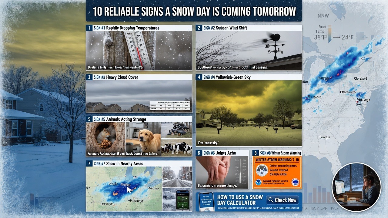
- Sign #1: Rapidly Dropping Temperatures
- Sign #2: A Sudden Shift in Wind Direction
- Sign #3: Heavy Cloud Cover Moving In
- Sign #4: The Sky Has a Yellowish or Green Tint
- Sign #5: Animals Acting Strange
- Sign #6: Your Joints or Body Aches (Barometric Pressure Drop)
- Sign #7: Snow Already Falling in Nearby Areas
- Sign #8: Meteorologists Issue a Winter Storm Watch or Warning
- Sign #9: The Dew Point and Humidity Align Perfectly
- Sign #10: School Districts Begin Pre-Emptive Communication
- How to Use a Snow Day Calculator for Accurate Predictions
- Conclusion: Be Prepared Before the First Flake Falls
Why Predicting a Snow Day Matters
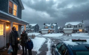
Few things stir up childhood excitement — or adult anxiety — quite like the prospect of a snow day. Whether you’re a student dreaming of sleeping in and sledding, a teacher adjusting lesson plans, or a working parent scrambling for backup childcare, knowing whether a snow day is likely before it happens is incredibly valuable.
Snow days don’t just appear out of nowhere. Atmospheric conditions, meteorological patterns, and even behavioral cues from nature telegraph incoming winter storms hours, sometimes days, in advance. Understanding these predictive signs — and knowing how to use tools like a Free Snow Day Calculator — puts you firmly ahead of the weather curve.
In this guide, we cover the 10 most reliable signs that a snow day is coming tomorrow, backed by meteorological science and real-world observation. Let’s dive in.
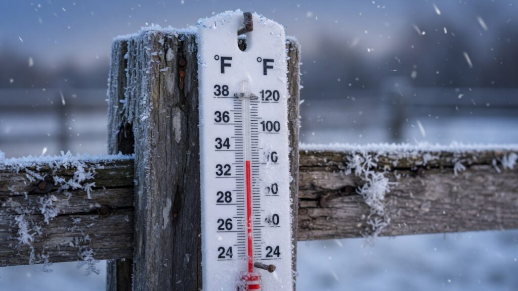
Sign #1: Rapidly Dropping Temperatures
The Science Behind the Temperature Plunge
One of the clearest early indicators of an incoming snowstorm is a rapid drop in ambient air temperature. When a cold air mass — typically an Arctic air mass or a polar vortex intrusion — pushes south, surface temperatures can plummet within just a few hours.
Meteorologists track this through surface analysis charts and upper-air soundings. When the 850-millibar temperature (roughly 5,000 feet above sea level) drops below –5°C to -10°C, heavy, wet, accumulating snow becomes highly probable at the surface level.
Key things to watch:
- Daytime high temperatures are significantly lower than yesterday’s
- Overnight lows are forecast well below the freezing point (32°F / 0°C)
- The temperature drop occurs suddenly, not gradually
If you notice the mercury nosediving by late afternoon, there’s a strong chance precipitation overnight will come down as snow rather than sleet or freezing rain.
Sign #2: A Sudden Shift in Wind Direction
Reading the Wind Like a Meteorologist
Wind direction is one of the most underappreciated predictors of winter precipitation. In North America, particularly in the Midwest, Northeast, and Great Plains, a shift in wind direction from the south or southwest to the north or northwest is a classic precursor to a winter storm system.
This directional shift is associated with the passage of a cold front — the boundary where cold, dense Arctic air overtakes warmer air masses. After the front passes, temperatures drop, humidity increases, and atmospheric pressure begins to fall sharply, creating conditions ripe for snow development.
What to observe:
- Wind shifts noticeably from a warm direction to a cold, northerly direction
- Wind speeds increase, creating a blustery, raw feel outdoors
- The wind carries a distinctly “cold” quality even before precipitation begins
Meteorologists call this the pre-frontal and post-frontal wind shift, and it’s one of the most consistent early-warning signals before significant snowfall events.
Sign #3: Heavy Cloud Cover Moving In
Cloud Types That Signal Snowstorms
Not all clouds are created equal when it comes to predicting snow. The arrival of specific cloud formations is one of the most visually identifiable signs that winter precipitation is on the way.
Clouds associated with incoming snowstorms:
| Cloud Type | Altitude | Snow Signal |
| Nimbostratus | Low-level | Steady, continuous snowfall |
| Altostratus | Mid-level | Thickening sky, precursor to snow |
| Cumulonimbus | Vertical | Heavy, convective snow squalls |
| Stratus | Very low | Light snow, freezing drizzle |
When you see the sky transition from partly cloudy to a thick, uniform grey blanket throughout the day — especially if that cloud deck lowers and thickens through the afternoon — snowfall is increasingly likely overnight.
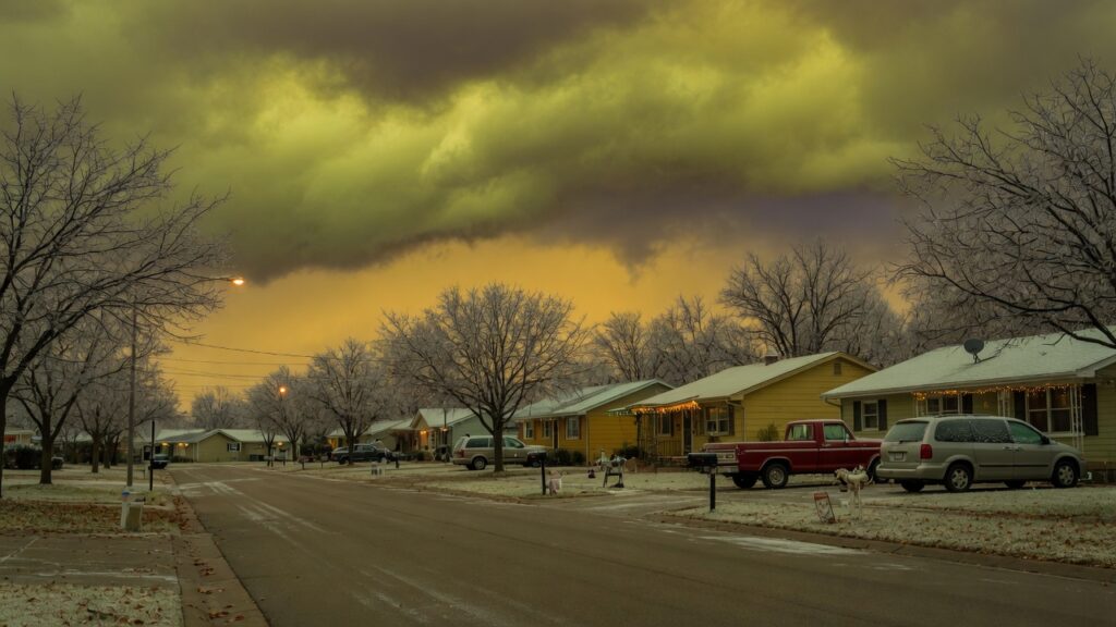
Sign #4: The Sky Has a Yellowish or Green Tint
Nature’s Own Warning Color
If you’ve ever looked outside before a major storm and noticed the sky taking on an eerie yellowish, orange, or greenish hue, you’ve witnessed one of nature’s most visually striking storm signals.
This phenomenon occurs because of the way light scatters through ice crystals and moisture-laden clouds at high altitudes. The incoming cirrus clouds and altostratus layers filter sunlight in a way that strips out blue wavelengths, leaving behind the warm yellows and amber tones that experienced weather watchers call the “snow sky.”
This is especially visible at sunrise or sunset in the hours before a major winter storm system arrives. Sailors and farmers have historically used this color shift as a reliable predictor — “Red sky at night, sailor’s delight; red sky in morning, sailor’s warning” is one of the oldest meteorological proverbs rooted in this reality.
Sign #5: Animals Acting Strange
What Wildlife Knows Before We Do
Animals — particularly birds, squirrels, dogs, and livestock — are remarkably sensitive to atmospheric pressure changes and electromagnetic fluctuations that precede severe winter weather. This is one of the oldest and most widely documented folk meteorology indicators, and modern science has confirmed there is a real biological basis behind it.
Animal behaviors to watch before snow:
- Birds: Flocking to feeders in unusually high numbers; flying low to the ground
- Squirrels: Hoarding food frantically and hiding deeper in nests
- Dogs: Restlessness, unusual howling, or refusing to go outside
- Cows: Lying down in pastures earlier than usual
- Insects: Disappearing completely from outdoor spaces
These behavioral changes are driven by the animal’s sensitivity to barometric pressure drops, which precede storm systems. Their inner ears, pressure-sensing organs, and instinctual storm-awareness are highly attuned to what’s coming.
Sign #6: Your Joints or Body Aches (Barometric Pressure Drop)
The Human Weather Forecast
If your knees, hips, or arthritis-affected joints start aching, pay attention — your body might be detecting an incoming storm before your smartphone does. This is not folklore; it’s grounded in physiology and atmospheric science.
When barometric pressure falls rapidly — a hallmark of an approaching storm system — the tissue around joints expands slightly due to reduced external pressure. For people with arthritis, old injuries, or chronic joint conditions, this expansion irritates already-inflamed tissue and nerve endings, causing the familiar pre-storm ache.
According to the National Weather Service, rapid pressure changes of 0.18 inches of mercury (inHg) or more within 24 hours often precede significant winter storm events. That’s the same pressure drop that makes your joints feel it first.
Sign #7: Snow Already Falling in Nearby Areas
Upstream Snowfall as a Predictive Signal
One of the most reliable signs that a snow day is coming to your area is checking whether snow is already falling in regions upwind and upstream from your location.
Storm systems move. Cold fronts sweep across the geography in consistent patterns. In the continental United States, weather systems predominantly move from west to east — meaning if Denver, Chicago, or Pittsburgh is getting hammered with snow right now, and you’re located to the east, it’s worth paying close attention.
How to track upstream snowfall:
- Check radar loops on weather apps for westward storm movement
- Follow social media posts from nearby cities and towns
- Look at satellite imagery of cloud movement patterns
This real-time tracking, combined with official forecasts, gives you a powerful early-warning picture before the first flake hits your zip code.
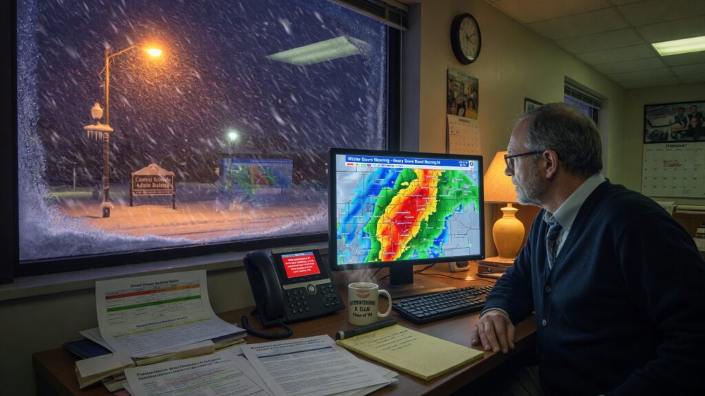
Sign #8: Meteorologists Issue a Winter Storm Watch or Warning
Understanding Official National Weather Service Alerts
When the National Weather Service (NWS) or your local meteorological authority issues an official alert, you should take it seriously. These agencies don’t issue watches and warnings lightly — they’re based on sophisticated numerical weather prediction models, upper-air data, and ensemble forecasting.
Understanding the alert hierarchy:
- Winter Weather Advisory: 2-4 inches of snow expected; travel may be impacted
- Winter Storm Watch: Significant snow likely within 48 hours; conditions favorable for 6+ inches
- Winter Storm Warning: Heavy snow imminent or occurring; 6+ inches expected; travel is dangerous
- Blizzard Warning: Sustained winds of 35+ mph with heavy snow and near-zero visibility
When a Winter Storm Watch or Warning is in place for your county, school cancellations and work closures follow closely behind. This is the most official sign that a snow day tomorrow is not just possible — it’s increasingly probable.
Sign #9: The Dew Point and Humidity Align Perfectly
The Meteorological Sweet Spot for Snow
This is the sign that separates casual weather watchers from true meteorology enthusiasts. Snow requires a very specific atmospheric recipe: cold temperatures AND sufficient moisture. Both conditions must align simultaneously.
The dew point — the temperature at which air becomes fully saturated with moisture — is the key variable. When the dew point is below freezing (32°F/0°C), and moisture is flowing into the atmosphere from a Gulf of Mexico surge, a Great Lakes moisture fetch, or a coastal storm system, the atmosphere has everything it needs to produce heavy snowfall.
The ideal snow conditions:
- Surface temperature: Below 32°F (0°C)
- Dew point: Below 30°F (-1°C)
- Relative humidity: 70–85%+
- Atmospheric lifting mechanism: Cold front, orographic lift, or surface low
When you check weather apps and see dewpoints in the mid-20s°F alongside sub-freezing temperatures and thickening clouds, snowfall is climatologically inevitable.
Sign #10: School Districts Begin Pre-Emptive Communication
The Administrative Signal You Shouldn’t Ignore
Here’s a sign that has nothing to do with meteorology and everything to do with institutional decision-making. When your school district, local government, or employer begins sending pre-emptive communications about potential closures, early dismissal options, or emergency plans, a snow day is likely already being considered by decision-makers.
School superintendents typically make closure decisions by 5:00–6:00 AM on the day of a potential storm. But before that, they’re monitoring forecasts closely, communicating with transportation directors, and sometimes tipping their hand through proactive emails or social media posts the evening before.
Signs of institutional preparation:
- School district posts about “monitoring the forecast” on social media
- Emergency alert tests sent via text or app the evening before
- After-school activities were proactively cancelled
- County road crews are salting streets in the late afternoon
When the administrators start hedging, the writing is on the wall — or rather, in the snow clouds.
How to Use a Snow Day Calculator for Accurate Predictions
Reading the signs above gives you powerful situational awareness, but combining that intuition with data-driven tools takes your prediction accuracy to another level.
A dedicated forecasting tool built specifically for snow day prediction accounts for factors that general weather apps overlook — including school district historical closure patterns, regional elevation, storm track probabilities, and local accumulation thresholds.
For a precise, easy-to-use prediction tool, try the Free Snow Day Calculator. Simply input your ZIP code and get an instant probability score for whether school will be cancelled tomorrow based on real-time forecast data.
If you’re new to the concept and want to understand exactly how these tools work and who benefits most from using them, check out our detailed guide: What Is a Snow Day Calculator and Who Should Use It.
These tools are especially valuable for:
- Parents planning childcare logistics the night before
- Students deciding whether to finish homework or go to sleep early
- Teachers preparing lesson plan contingencies
- Remote workers scheduling meetings around weather disruptions
CONCLUSION
Be Ready Before the First Flake Falls
Predicting a snow day is equal parts science, observation, and awareness. By watching for rapidly dropping temperatures, shifting wind patterns, unusual cloud formations, animal behavior changes, and official meteorological warnings — and by understanding the atmospheric physics behind each signal — you can forecast your snow day odds with remarkable accuracy.
The combination of nature’s own signals, institutional cues, and modern digital tools gives today’s weather-aware individual more predictive power than ever before. Don’t get caught off guard by winter’s most exciting disruption. Use the signs in this guide, keep a close eye on official forecasts, and let a Free Snow Day Calculator do the data-heavy lifting for you.
Winter storms are inevitable. Being prepared — and maybe even a little excited — is entirely up to you. ❄️