Summary
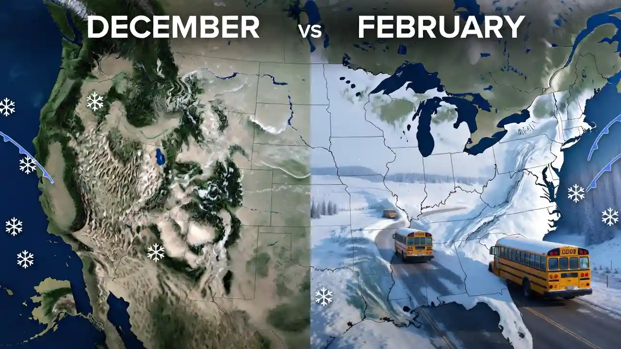
February Gets More Snow Days Than December because winter weather in many U.S. states does not reach its strongest setup at the start of the season. By February, colder ground, deeper seasonal air masses, active storm tracks, lake-effect patterns, and better moisture-cold air overlap all make snow days more likely than they are in December. December feels like the beginning of winter, but in many regions, the atmosphere is still transitioning out of fall. February often brings the mature version of winter, when conditions are more consistently cold and storms have a better chance of producing school-closing snow.
Table of Content
- Why February Gets More Snow Days Than December Across Most States
- The Science Behind Late-Winter Snow Days
- Why December Often Underperforms for Snow
- Regional Reasons February Gets More Snow Days Than December
- How Storm Tracks, Cold Air, and Moisture Work Together
- Why Snow Days Are Not Just About Snowfall Totals
- What Parents and Schools Should Expect in February
- Conclusion
- FAQs
Why February Gets More Snow Days Than December Across Most States
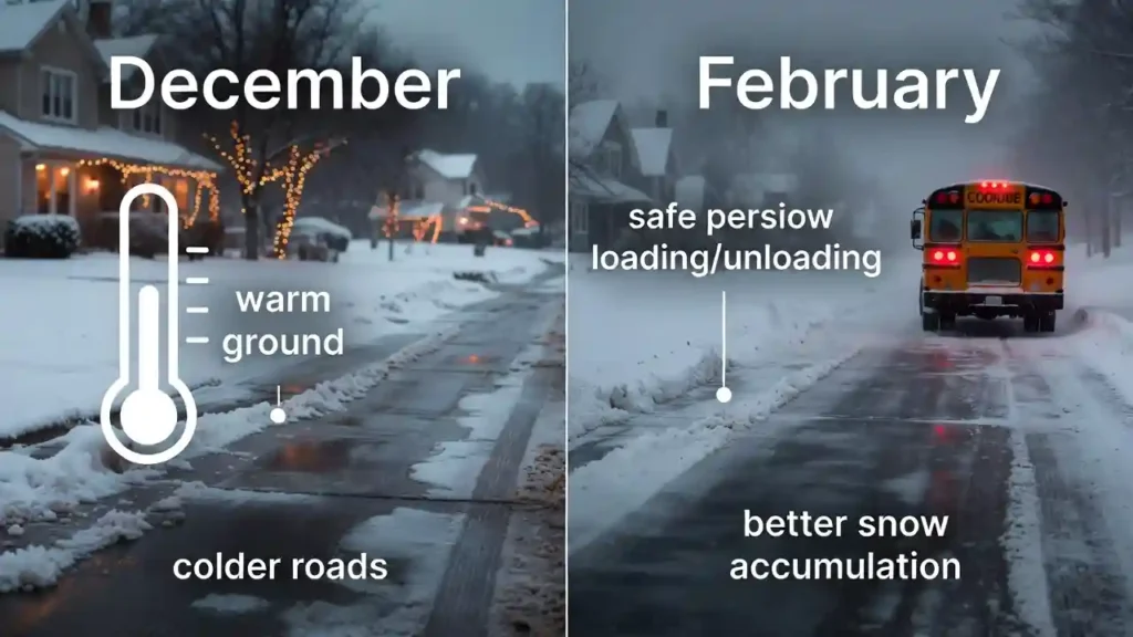
Many people assume December should be the snowiest month because it marks the start of winter, brings holiday imagery, and often feels like the month when snow “should” arrive. In reality, February is often better positioned to create disruptive snow days across much of the United States.
The reason is simple at first glance but more complex once we look at the atmosphere. Snow days require more than snowflakes. They require cold air at the surface, moisture, storm timing, road impacts, school transportation concerns, and enough accumulation or ice risk to interrupt daily life. February often checks more of those boxes than December.
December sits at the front edge of winter. Many states are still carrying leftover autumn warmth in the ground, lakes, rivers, and lower atmosphere. A December storm can bring precipitation, but if temperatures hover near freezing, that precipitation may fall as rain, sleet, wet snow, or a short-lived mix. Even when snow falls, it may melt on contact with roads that have not yet cooled enough.
February is different. By then, winter has had weeks to settle in. Cold air has repeatedly pushed south from Canada. Soil temperatures are lower. Lakes have cooled, though some may still provide moisture for lake-effect snow. Snowpack in northern areas can reinforce cold air. Storm systems moving across the country are more likely to meet an atmosphere already cold enough to support snow.
This is why the phrase “February snow day” makes sense in many states. December introduces winter. February often delivers it.
For parents trying to plan around school closures, transportation delays, and morning weather uncertainty, tools such as the Snow Day Predictor can help turn local forecast details into a clearer expectation of whether school disruption is likely.
The Science Behind Late-Winter Snow Days
A snow day is not created by snowfall alone. It forms when weather, infrastructure, timing, and public safety overlap. February has several physical advantages over December that increase the odds of this overlap.
Colder Ground Helps Snow Stick
One of the most overlooked differences between December and February is ground temperature. In December, pavement, soil, and building surfaces may still hold heat from autumn. This matters because early-season snow often melts as soon as it hits roads, sidewalks, and driveways.
By February, the ground has usually lost much more of its stored warmth. Even a moderate snowfall can accumulate more efficiently. Roads become slick faster, untreated surfaces freeze more easily, and plowed snow can refreeze overnight. These conditions make school transportation more difficult, especially in rural districts with long bus routes.
Snow accumulation is not only about what falls from the sky. It is also about what survives after landing.
February Has a Stronger Cold-Air Foundation
Snow needs cold air through a deep enough layer of the atmosphere. In December, storms often arrive while cold air is still shallow or inconsistent. A warm layer just above the surface can turn snow into sleet or freezing rain. A slightly warmer surface layer can make the whole event mostly rain.
February typically has a better cold-air foundation. Arctic outbreaks and polar air masses have had more time to reach deeper into the United States. The jet stream is often still active, and when storm systems meet entrenched cold air, widespread snow becomes more likely.
This is especially important in the Midwest, Northeast, Great Lakes region, northern Plains, and interior mountain states. These areas may get snow in December, but February often has more reliable cold support.
Moisture and Cold Air Overlap More Often
The ideal snowstorm needs cold air and moisture in the same place at the same time. December can have plenty of moisture, especially from Gulf systems, Pacific storms, or coastal lows. The problem is that the cold air is not always in place yet.
In February, storm tracks can still supply moisture while the continent remains cold enough for snow. This overlap is one of the main reasons February can produce more snow days than December in many states.
When a low-pressure system pulls moisture northward and cold air holds firm near the surface, snow can spread across large regions. If the storm arrives overnight or during the early morning commute, school closures become more likely.
Why December Often Underperforms for Snow
December has a strong winter identity, but meteorologically it is often a transition month. That transition can limit snow days.
December Still Carries Autumn Warmth
The atmosphere does not instantly become winter on December 1. In many states, November and early December still include mild spells. The sun angle is low, but the land and water have not fully cooled. This leftover warmth can reduce snow accumulation, especially during marginal storms.
In the Mid-Atlantic, Ohio Valley, southern New England, parts of the central Plains, and lower-elevation western states, December storms often fall into the frustrating category of “almost snow.” Forecasts may show potential, but a few degrees can decide whether students wake up to a snow day or just a cold rain.
Early-Season Storms Are Often Messier
December storms are more likely to bring mixed precipitation. That can mean rain changing to snow, snow changing to rain, sleet, freezing rain, or a narrow band of accumulation surrounded by wet roads.
Mixed precipitation can still be dangerous, but it does not always lead to classic snow days. School districts often weigh road treatment, bus safety, expected timing, and temperature trends. If snow is brief or roads remain mostly wet, schools may stay open.
By February, storms are more likely to produce snow from start to finish in colder regions. That consistency makes impacts easier to anticipate and closures more likely.
Holiday Break Reduces Counted School Snow Days
There is also a practical reason December may appear to have fewer snow days: many schools are closed for winter break during part of the month. If a snowstorm happens during holiday vacation, it does not become a school snow day.
February usually has fewer long breaks for most districts, aside from Presidents’ Day or occasional midwinter breaks. A storm that hits on a regular February weekday is more likely to be recorded by families as a true snow day.
This difference matters when people compare “snow days” rather than total snowfall. December may have storms, but some of them occur when school is already out.
Regional Reasons February Gets More Snow Days Than December
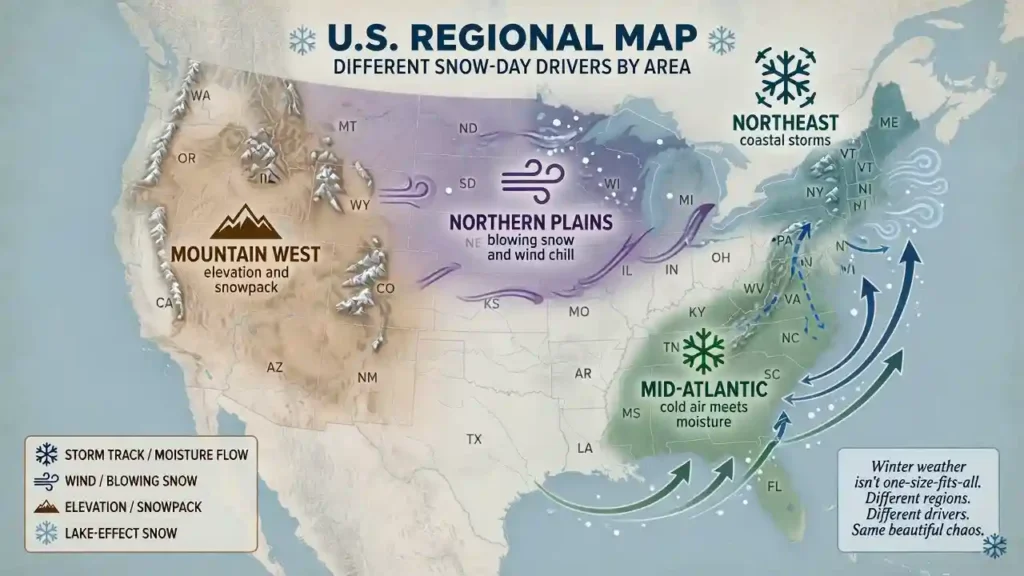
Snow patterns vary widely across the United States. Still, several regional patterns help explain why February can outperform December for snow days.
Northeast and New England
In the Northeast, February often has stronger cold air and active coastal storm potential. Nor’easters can form when low-pressure systems intensify along the Atlantic coast, pulling moisture into entrenched cold air. These storms can bring heavy snow, wind, coastal impacts, and widespread school closures.
December nor’easters do happen, but early-season warmth can push the rain-snow line farther inland. Cities near the coast may see rain or mixed precipitation in December while interior areas get snow. By February, colder air often allows snow to reach farther south and east.
Midwest and Great Lakes
The Midwest and Great Lakes region often sees more reliable winter conditions by February. Cold air is well established, storm systems move along active tracks, and lake-effect snow remains a major factor where open water and cold air interact.
Lake-effect snow is especially important downwind of the Great Lakes. When cold air passes over relatively warmer lake water, it picks up moisture and deposits snow over favored areas. December can be productive for lake-effect snow because the lakes are often still unfrozen and relatively warm. However, February can still produce significant lake-effect events when enough open water remains and the cold air is strong.
For school districts in Michigan, Ohio, Indiana, Pennsylvania, Wisconsin, and New York, localized snow bands can create major differences over short distances. One town may have manageable roads while another nearby district closes because a heavy band sits over bus routes.
Northern Plains and Upper Midwest
In the northern Plains and Upper Midwest, February often brings intense cold, blowing snow, and dangerous wind chills. Snow days in these states are not always caused by fresh snowfall alone. Sometimes schools close because existing snow is blowing across roads or because wind chills create unsafe conditions for children waiting at bus stops.
December can be snowy, but February often has deeper snowpack and harsher cold. That combination increases the chance of drifting, reduced visibility, and road closures after storms.
Mountain West
In the Rockies, Cascades, Sierra Nevada, and interior West, February can be one of the stronger months for mountain snowpack. Pacific storm systems, elevation, and cold air combine to produce significant snowfall. Snow days in mountain communities may depend on pass closures, avalanche control, road maintenance, and bus access.
December storms can build early snowpack, but February often benefits from a more mature winter storm cycle. Higher elevations may see frequent snow, while valleys experience a mix of snow, rain, and freezing conditions depending on elevation and local geography.
Mid-Atlantic and Interior South
The Mid-Atlantic and parts of the interior South often have marginal winter temperatures. In these regions, February can be more favorable than December because the cold air is more likely to reach far enough south.
States such as Virginia, Maryland, Kentucky, Tennessee, North Carolina, and parts of Arkansas or Oklahoma can see high-impact winter storms when Gulf moisture meets cold air. These events may not happen often, but when they do, February is frequently better positioned than December for snow or ice.
A small amount of snow or freezing rain can close schools in areas with limited snow-removal infrastructure. That means February does not need to produce huge totals to create more disruption.
How Storm Tracks, Cold Air, and Moisture Work Together
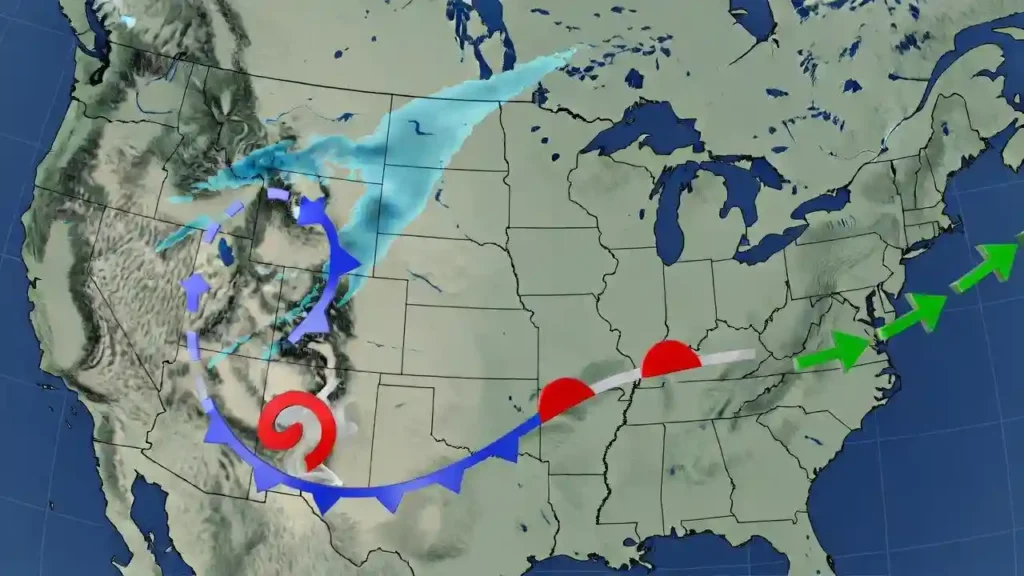
To understand why February is often snowier for school impacts, it helps to think of snow days as the result of three ingredients.
Ingredient 1: A Storm Track
Storms need a path. In winter, low-pressure systems often move from the Pacific into the West, from the southern Plains toward the Great Lakes, or up the East Coast. These tracks determine where precipitation falls.
A storm that tracks too far west may pull warm air north and change snow to rain. A storm that tracks too far south may miss a region entirely. The most disruptive snow often happens on the cold side of a storm track, where moisture is lifted over cold air.
Ingredient 2: Cold Air in Place
Cold air must be present before or during the storm. In December, cold air may arrive behind the storm, which is too late for snow. In February, cold air is more likely to already be in place. That gives precipitation a better chance of falling as snow from the beginning.
The timing of cold air is crucial. A storm that starts as rain and ends with flurries rarely causes the same disruption as one that begins as snow during the pre-dawn hours.
Ingredient 3: Moisture Supply
Cold air alone does not create snow. The atmosphere also needs moisture. February storms can tap moisture from the Gulf of Mexico, Atlantic Ocean, Pacific Ocean, or Great Lakes. When that moisture interacts with cold air, snowfall rates can increase quickly.
Heavy snowfall rates matter because roads can become snow-covered faster than crews can treat them. A storm dropping one inch per hour during the morning commute may cause more school disruption than a slow overnight snowfall of the same total amount.
Why Snow Days Are Not Just About Snowfall Totals
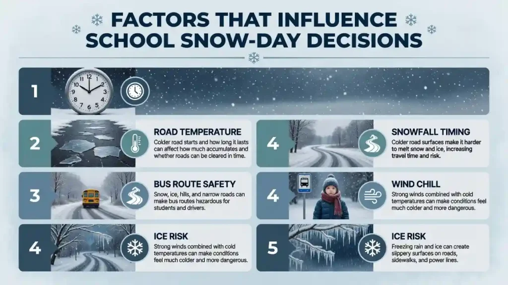
A common mistake is assuming the biggest snowfall always creates the most likely snow day. School closures depend on impact, not just inches.
Timing Can Matter More Than Total Snow
A three-inch snowfall from midnight to 4 a.m. may be cleared before buses run. The same three inches falling from 6 a.m. to 9 a.m. can create dangerous travel conditions. February storms often occur in colder conditions that allow snow to accumulate quickly during high-impact travel windows.
Road Temperature Changes the Outcome
Road temperature can determine whether snow melts, sticks, compacts, or freezes. December roads may be warm enough to handle light snow. February roads are more likely to be cold, which helps snow stick and ice form.
This is why two storms with the same air temperature and snowfall forecast can have different school outcomes depending on the month.
District Size and Terrain Matter
Large school districts must consider conditions across many roads. Rural districts may close because bus routes include untreated roads, hills, bridges, or open areas where snow drifts. Mountain districts may close because of pass conditions. Urban districts may stay open if major roads are treated quickly, but sidewalks and neighborhood streets can still complicate decisions.
February increases the chance that these local vulnerabilities become serious enough to affect school schedules.
What Parents and Schools Should Expect in February
February is often the month when winter fatigue sets in. Families have already dealt with cold mornings, short days, and changing forecasts. Yet this is also when many regions face some of their most realistic snow-day threats.
Parents can prepare by watching not just snowfall totals, but also timing, temperature, wind, and road conditions. A forecast of two to four inches may be more serious if it arrives before school, falls on frozen roads, or comes with gusty winds.
For a deeper look at family routines, emergency planning, and practical winter habits, read What Parents in Cold Climates Do Differently to Prepare.
Schools typically look at several factors before closing:
Bus Safety
School buses are large, heavy vehicles that need extra stopping distance on snow or ice. Rural routes, hills, and untreated roads increase risk.
Forecast Confidence
Districts must decide early, often before a storm fully develops. February storms may have stronger signals because cold air is more established, but small changes still matter.
Wind Chill and Visibility
In northern states, schools may close even when little new snow falls. Blowing snow, drifting, whiteout conditions, and dangerous wind chills can be enough.
Ice Risk
Some February systems produce sleet or freezing rain, especially near the rain-snow line. Ice can be more disruptive than snow because it affects roads, sidewalks, trees, and power lines.
External Climate Reference
For readers who want to explore long-term U.S. snowfall and climate averages, NOAA’s U.S. Climate Normals provide official 30-year climate averages for thousands of weather stations. These normals help explain why “typical” winter conditions vary so much between states, cities, elevations, and regions.
Conclusion
February gets more snow days than December in many states because winter is more fully developed by late season. The ground is colder, the air is more consistently below freezing, storm tracks remain active, and moisture has a better chance of meeting cold air at the right time. December may look like winter on the calendar, but it often behaves like a transition month.
The difference is especially clear when we focus on school closures rather than snowfall totals alone. Snow days depend on timing, road conditions, bus safety, wind, ice, and local infrastructure. February often creates more disruptive combinations of those factors.
For families, the lesson is practical: do not let the calendar fool you. December may bring the first excitement of winter, but February often brings the higher-risk setup for school delays, closures, and serious winter travel problems.
FAQs
1. Why does February get more snow days than December?
February often has colder ground, stronger cold air, and better overlap between moisture and freezing temperatures. December is usually still transitioning from fall, so storms are more likely to produce rain, mixed precipitation, or snow that melts quickly.
2. Is February always snowier than December?
No. Snow patterns depend on location, elevation, storm tracks, and yearly climate patterns. Some places get major December snow, especially in the mountains and near the Great Lakes. However, many states have more favorable snow-day conditions in February.
3. Why does December snow melt faster?
December snow often falls on warmer roads, sidewalks, and soil because the ground still holds heat from autumn. By February, surfaces are usually colder, so snow sticks and accumulates more efficiently.
4. Do schools close more often in February?
In many colder and transitional climates, February can produce more school closures because storms are more likely to affect roads during established winter conditions. However, closure patterns vary by district, local policy, and storm timing.
5. Can a small February snowfall cause a snow day?
Yes. A small snowfall can close schools if it arrives during the morning commute, falls on frozen roads, includes ice, or affects rural bus routes. Timing and road conditions can matter as much as total snowfall.
6. Why does February still get strong storms if winter is almost over?
Meteorological winter includes December, January, and February. By February, the atmosphere can still support strong storm systems, and cold air is often well established. Spring warming usually becomes more influential later.
7. Which regions are most likely to see February snow days?
The Northeast, Great Lakes, Midwest, northern Plains, Mountain West, and parts of the Mid-Atlantic often see significant February snow-day potential. Interior southern states can also experience disruptive snow or ice when cold air reaches far enough south.
8. What should parents watch in a February forecast?
Parents should look at snowfall timing, road temperature, wind chill, ice potential, and whether snow is expected during bus pickup or commute hours. These details often matter more than the headline snowfall total.